"We are not used to this in September". Temperatures in Faro reach 35 degreesPhoto by Laura Oliveira on Pexels
Weather
Транспорт
Faro

"We are not used to this in September". Temperatures in Faro reach 35 degrees

CNN Portugal3 September 2026 at 12:00

Temperatures continue to rise in Portugal, with the Algarve recording the highest values. At Faro Airport, thermometers reached 35 degrees, a value considered abnormal for this time of year. The phrase "We are not used to this in September" summarizes the widespread feeling regarding this episode of late heat.

Related articles

Weather

Current episode of El Niño phenomenon could be "the most intense" in the last 40 years

The current episode of the El Niño phenomenon could be "the most intense" in the last forty years, since measurements of this climate phenomenon began, according to the United Nations World Meteorological Organization (WMO).

Açoriano Oriental03/09/26, 13:12
Weather

What does an <em>El Niño</em> with 100% probability mean? Seven questions and answers

The article discusses the El Niño phenomenon with 100% probability of occurrence, explaining that it could become more intense than any other recorded during more than four decades of modern monitoring. Through seven questions and answers, the text aims to clarify the meaning and implications of this climate event that affects global weather patterns.

Público03/09/26, 12:58
Weather

"Temperatures will drop on Friday" but the heat will return quickly

Temperatures have risen again across the country, with southern Portugal recording the highest thermometer readings. IPMA meteorologist Jorge Ponte explains that this thermal rise is due to specific atmospheric conditions, although a drop in temperatures is forecast for next Friday. However, according to the forecasts, the heat should return quickly after this brief pause.

CNN Portugal03/09/26, 12:33
Há um comboio de três furacões a atravessar o Pacífico. O El Nino já mostra a sua fúria
Weather

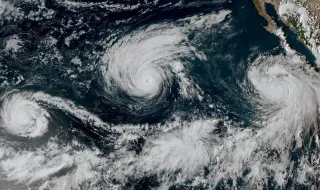
There is a train of three hurricanes crossing the Pacific. El Niño is already showing its fury

Three hurricanes are simultaneously crossing the Pacific Ocean, a phenomenon considered rare by scientists. Hurricane Marie recently transformed into a hurricane of as yet unspecified category off the coast of Baja California, followed by hurricanes Karina and Lowell, both category 4, heading west. Scientists attribute this trio of storms to abnormally warm waters caused by a historically strong El Niño, which creates ideal conditions for the formation and intensification of these storms, which depend heavily on warm waters to feed on.

ZAP Notícias03/09/26, 12:30