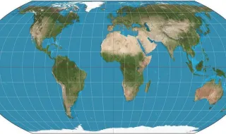
The United Nations General Assembly approved this Friday a historic resolution that will change the way we see the world map. The reign of over 450 years of the Mercator projection comes to an end, which distorts the sizes of continents and has been used for centuries in navigation and schools.
The new resolution establishes parameters for the adoption of a more precise representation of the planet, correcting the disproportions that have always favored the Eurocentric view of the world. The Mercator projection, created in 1569, uncontrollably enlarged areas near the poles, making countries like Greenland and Antarctica much larger than they actually are.
The change has significant implications for education, for official cartography, and for how different cultures and nations see themselves represented on the global stage. Experts point out that the new representation offers a more balanced and fair view of actual territorial proportions.