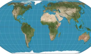
The United Nations General Assembly approved a resolution titled "Correcting the Map," presented by Togo with the support of the African Union, which aims to promote a more accurate cartographic representation of continents, especially Africa. The resolution was approved with 164 votes in favor, one against from the United States, and six abstentions from Estonia, Georgia, Lithuania, Moldova, Serbia, and Ukraine.
The proposal advocates abandoning the Mercator projection, developed in the 16th century, which makes Africa appear much smaller than it actually is, while visually exaggerating regions near the poles. In reality, the African continent is about 14 times larger than Greenland, which appears with similar sizes on current maps. The resolution encourages the adoption of the Equal Earth projection, which shows countries and continents in proportional sizes.
Togo argued that map distortions have caused significant consequences over time, contributing to symbolically minimizing Africa's size and creating an unbalanced view of global geography. Togo's Minister of Foreign Affairs, Robert Dussey, stated that the initiative "is about cognitive justice, about access to precise geographic knowledge, the dignity of peoples, historical memory, and the fight against inherited representations."
The United States was the only country to vote against the resolution, considering it "ridicules the work and purpose" of the UN and that it is part of a "larger and more radical ideological project." The vote took place in the same week that President Donald Trump proposed renaming the Strait of Hormuz as "Trump Strait" and signed an executive order to change the name of Lake Ontario to "Lake America." Since General Assembly resolutions do not have binding legal force, effective implementation depends on the political will of member states and international organizations.